Hierarchical Regularization of Building Boundaries in Noisy Aerial Laser Scanning and Photogrammetric Point Clouds.
Jan 1, 2018·
,
 ,
,
,
,
·
0 min read
,
,
,
,
·
0 min read
L. Xie
Q. Zhu*
Han Hu
B. Wu
Y. Li
Y. Zhang
R. Zhong
Abstract
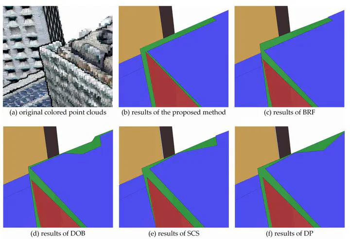
Aerial laser scanning or photogrammetric point clouds are often noisy at building boundaries. In order to produce regularized polygons from such noisy point clouds, this study proposes a hierarchical regularization method for the boundary points. Beginning with detected planar structures from raw point clouds, two stages of regularization are employed. In the first stage, the boundary points of an individual plane are consolidated locally by shifting them along their refined normal vector to resist noise, and then grouped into piecewise smooth segments. In the second stage, global regularities among different segments from different planes are softly enforced through a labeling process, in which the same label represents parallel or orthogonal segments. This is formulated as a Markov random field and solved efficiently via graph cut. The performance of the proposed method is evaluated for extracting 2D footprints and 3D polygons of buildings in metropolitan area. The results reveal that the proposed method is superior to the state-of-art methods both qualitatively and quantitatively in compactness. The simplified polygons could fit the original boundary points with an average residuals of 0.2 m, and in the meantime reduce up to 90% complexities of the edges. The satisfactory performances of the proposed method show a promising potential for 3D reconstruction of polygonal models from noisy point clouds.
Publication
Remote Sensing,