Semantic maps for cross-view relocalization of terrestrial to UAV point clouds
Nov 1, 2022·
,
,
,
,
 ,
·
0 min read
,
·
0 min read
Xuming Ge
Yuting Fan
Qing Zhu
Bin Wang
Bo Xu
Han Hu
Min Chen
Abstract
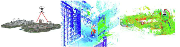
To generate a complete 3D point cloud model for complex urban environments, data must be captured from both top-view and street-view sides due to the limited field of view of the sensors. Unmanned aerial vehicle-laser scanning (UAV-LS) point clouds are captured from a top view, and they often contain information about building roofs and tree crowns. In contrast, terrestrial point clouds, collected by terrestrial laser scanners (TLS) and mobile laser scanners (MLS), are captured from a street view and contain information about building facades and tree stems. These two types of point clouds are challenging to register without manual efforts or target-based assistance because of (1) very limited overlapping regions caused by the cross-view and (2) the wide search of regions for the automatic localization of terrestrial scans in a large-scale scene from a UAV scan. Consequently, we highlight that a semantic map can be developed by utilizing the invariant semantic and geometric relationships to automatically locate from a local scan to a global scan. In our tasks, the buildings and tree regions are detected and assigned as semantic objects and input to generate a 2.5D semantic map related to their actual location information. We propose a novel template matching strategy combined with a penalty system to realize the localization. Specifically, the templates can be produced by the obtained semantic maps, and then the best localization can be achieved by a graded punishment method based on the developed rules. We emphasize that the proposed method can handle the integration of multiple-aligned scans and even a single scan by using a terrestrial scanner to a UAV scan owing to the stability and continuity of semantic information. In the experiments, we used a UAV to capture the lidar point clouds over the campus of the Southwest Jiaotong university and generated a global semantic map offline. Keeping the global map in hand, we collected the data from the street views by TLS and MLS also the campus and then implemented the localization from TLS/MLS point clouds to the UAV point clouds. The evaluations are grouped into two grades related to the degree of difficulty: (1) the regular group, which contains the multiple-registered TLS scans and MLS scans, and (2) the challenging group, which has independent TLS scans. In general, from the experimental results, for the proposed method, the success rate of localization is up to 100% in the regular group and 90% in the challenging group, indicating that only one in ten tests fails for the challenging group.
Publication
International Journal of Applied Earth Observation and Geoinformation