Integration of Chang'E-2 Imagery and LRO Laser Altimeter Data with a Combined Block Adjustment for Precision Lunar Topographic Modeling
Abstract
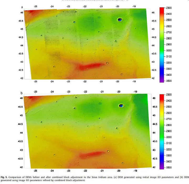
Lunar topographic information is essential for lunar scientific investigations and exploration missions. Lunar orbiter imagery and laser altimeter data are two major data sources for lunar topographic modeling. Most previous studies have processed the imagery and laser altimeter data separately for lunar topographic modeling, and there are usually inconsistencies between the derived lunar topographic models. This paper presents a novel combined block adjustment approach to integrate multiple strips of the Chinese Chang’E-2 imagery and NASA’s Lunar Reconnaissance Orbiter (LRO) Laser Altimeter (LOLA) data for precision lunar topographic modeling. The participants of the combined block adjustment include the orientation parameters of the Chang’E-2 images, the intra-strip tie points derived from the Chang’E-2 stereo images of the same orbit, the inter-strip tie points derived from the overlapping area of two neighbor Chang’E-2 image strips, and the LOLA points. Two constraints are incorporated into the combined block adjustment including a local surface constraint and an orbit height constraint, which are specifically designed to remedy the large inconsistencies between the Chang’E-2 and LOLA data sets. The output of the combined block adjustment is the improved orientation parameters of the Chang’E-2 images and ground coordinates of the LOLA points, from which precision lunar topographic models can be generated. The performance of the developed approach was evaluated using the Chang’E-2 imagery and LOLA data in the Sinus Iridum area and the Apollo 15 landing area. The experimental results revealed that the mean absolute image residuals between the Chang’E-2 image strips were drastically reduced from tens of pixels before the adjustment to sub-pixel level after adjustment. Digital elevation models (DEMs) with 20 m resolution were generated using the Chang’E-2 imagery after the combined block adjustment. Comparison of the Chang’E-2 DEM with the LOLA DEM showed a good level of consistency. The developed combined block adjustment approach is of significance for the full comparative and synergistic use of lunar topographic data sets from different sensors and different missions.
Publication
Earth and Planetary Science Letters