Cascaded Residual Attention Enhanced Road Extraction from Remote Sensing Images
Jan 1, 2022·
,
,
 ,
,
,
,
,
,
·
0 min read
,
,
,
,
,
,
·
0 min read
Shengfu Li
Cheng Liao
Yulin Ding*
Han Hu
Yang Jia
Min Chen
Bo Xu
Xuming Ge
Tianyang Liu
Di Wu
Abstract
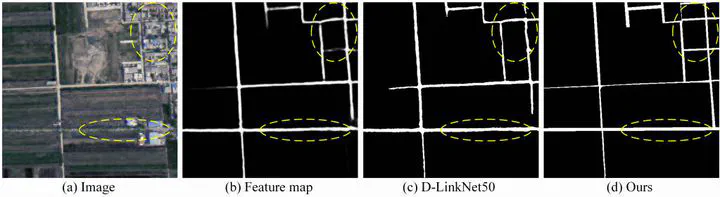
Efficient and accurate road extraction from remote sensing imagery is important for applications related to navigation and Geographic Information System updating. Existing data-driven methods based on semantic segmentation recognize roads from images pixel by pixel, which generally uses only local spatial information and causes issues of discontinuous extraction and jagged boundary recognition. To address these problems, we propose a cascaded attention-enhanced architecture to extract boundary-refined roads from remote sensing images. Our proposed architecture uses spatial attention residual blocks on multi-scale features to capture long-distance relations and introduce channel attention layers to optimize the multi-scale features fusion. Furthermore, a lightweight encoder-decoder network is connected to adaptively optimize the boundaries of the extracted roads. Our experiments showed that the proposed method outperformed existing methods and achieved state-of-the-art results on the Massachusetts dataset. In addition, our method achieved competitive results on more recent benchmark datasets, e.g., the DeepGlobe and the Huawei Cloud road extraction challenge.
Publication
ISPRS International Journal of Geo-Information